
Description
Big news. A full QWERTY keyboard lets you easily type messages. Wander wider and still stay in touch — with inReach for messaging and 24/7 SOS. (active satellite subscription required). Routable TopoActive Australia and New Zealand maps. Now you’re free to take it off-road or on. Meets MIL-STD 810 for thermal, shock, water and vibration. Available inReach weather forecast service provides detailed updates directly to your Montana 700i handheld. Get the clear perspective of BirdsEye Satellite Imagery right to your GPS device. Power your adventures with 18+ hours of lithium-ion battery life in GPS mode, or use Expedition mode, an ultralow-power GPS reference, to keep Montana tracking for a week or more between recharges. DIMENSION 9.19 x 18.30 x 3.27 cm TOUCHSCREEN DISPLAY SIZE 6.48 x 10.80 cm; 5″ diag (12.70 cm) DISPLAY RESOLUTION 480 x 800 pixels DISPLAY TYPE WVGA transflective, dual orientation WEIGHT 410 g with included lithium-ion battery pack BATTERY TYPE rechargeable lithium-ion (included) BATTERY LIFE GPS Mode: up to 18 hours Expedition Mode: up to 330 hours GPS Mode, 10 min Tracking: up to 18 hours Expedition Mode, 30 min Tracking: up to 300 hours IPX7 MIL-STD-810 yes (thermal, shock, water, vibe) INTERFACE High speed micro USB and NMEA 0183 compatible MEMORY/HISTORY 16 GB (user space varies based on included mapping) PRELOADED MAPS Yes (Topo for Australia & New Zealand) ABILITY TO ADD MAPS Yes BASEMAP Yes AUTOMATIC ROUTING (TURN BY TURN ROUTING ON ROADS) FOR OUTDOOR ACTIVITIES Yes AUTOMATIC ROUTING (TURN BY TURN ROUTING ON ROADS) FOR MOTORIZED VEHICLES Yes MAP SEGMENTS 15000 BIRDSEYE Yes (direct to device) INCLUDES DETAILED HYDROGRAPHIC FEATURES (COASTLINES, LAKE/RIVER SHORELINES, WETLANDS AND PERENNIAL AND SEASONAL STREAMS) Yes INCLUDES SEARCHABLE POINTS OF INTERESTS (PARKS, CAMPGROUNDS, SCENIC LOOKOUTS AND PICNIC SITES) Yes DISPLAYS NATIONAL, STATE AND LOCAL PARKS, FORESTS, AND WILDERNESS AREAS Yes EXTERNAL MEMORY STORAGE Yes (32 GB max microSD™ card) WAYPOINTS/FAVORITES/LOCATIONS 10000 TRACKS 250 NAVIGATION TRACK LOG 20000 points, 250 saved gpx tracks, 300 saved fit activities NAVIGATION ROUTES 250, 250 points per route; 50 points auto routing RINEX LOGGING Yes HIGH-SENSITIVITY RECEIVER Yes GPS Yes GALILEO Yes BAROMETRIC ALTIMETER Yes COMPASS Yes (tilt-compensated 3-axis) GPS COMPASS (WHILE MOVING) Yes
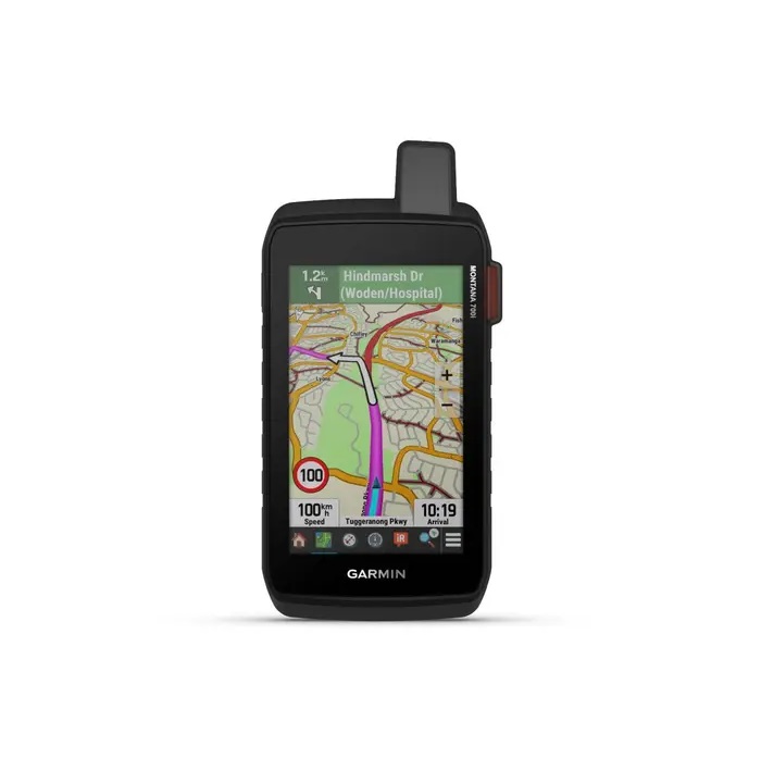
The Montana 700i handheld combines the flexibility of on- or off-road navigation with global messaging and interactive SOS via inReach satellite technology.
Sensors
Need some questions answered? Want to see the rest of our range? Click below to call us at Electric Bug or keep browsing our website!


Reviews
There are no reviews yet